Route calculation is done through the Google Maps API and has certain constraints. You can only make a limited number of posts per day. Since the calculation of the optimal route is done on your computer, complicated routes may become too demanding to calculate an optimal route. In addition, it will not be possible to calculate routes for trips with more than 50 waypoints.But in many cases, the tool will work and you will find it under
| Table of Contents | ||
|---|---|---|
|
Cachetur uses GraphHopper to determine the best order to find caches. The tool will optimize up to 80 waypoints at a time using streets and trails available through OpenStreetMap (OSM) and only requires the user to identify the waypoints to be sorted, where to start, and where to end.
After adding your caches and other coordinate-based waypoints to the trip, find the route optimizer in "Edit trip"-->" Sort/prioritize waypoints." (Note that this menu only exists while viewing a trip.)
First choose the waypoints
Before we can calculate an optimal route, we need to select which waypoints to calculate a route for. We do this by clicking "Mark" in the waypoint list.
(note the first waypoint in the list will always be the start point, and the last will always be the stop point)
(we can also use the toggle marked button
to select all caches)
Once we have marked the caches we wish to calculate we click "Use selected waypoints"
Choose calculation method
After we have selected the waypoints we can choose between "as the crow flies" and "route along road"
Direct route (as the crow flies)
Direct route calculation allows you to calculate optimal route based on distance as the crow flies.
This works best for caches that are not in a big cluster, but rather in a long row.
It also works for waypoints that are "off road".
Routing along a road
Routing along the road gives you a more accurate route in places where driving directions, small roads, closed roads, etc. make a big difference. It also takes time into account.
Routing along the way is done through Google Maps, and if you have caches that are not along a "routeable road", the route will not work.
Calculation and sorting
When the calculation has started we will se an progressindicator an a status box telling us the remaining time.
When the calculations are done, you will see the optimized route (no route is displayed for direct route, only waypoints)
...
Select waypoints
"Mark" the waypoints to be optimized by selecting the "Mark" button on the right side. To quickly select all waypoints, click  .
.
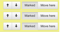
In the list of selected waypoints, the first waypoint will be the start, and the last waypoint will be the end. The tool will sort the remaining waypoints while respecting the start and end points. You can manually change the start and end points by moving their location in the list of selected waypoints. For more information on sorting waypoints, please see Sorting waypoints.
Optimize route
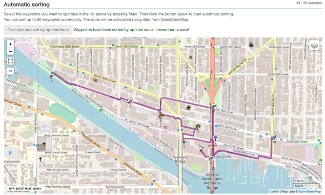
After selecting the waypoints to sort, scroll down to "Automatic sorting" and press  to sort the waypoints.
If the button is not active, confirm that the number of waypoints does not exceed 80; change selections as necessary to adjust the number of waypoints.

Confirm sorting and save
After a few seconds (yes, this route calculation is fast), a confirmation and map will appear with the optimized sort order.
Review the route to ensure it makes sense. If any manual changes should be made, do so in the list above by Sorting waypoints. When you are happy with your sort order, make sure to click  to lock-in and store the new sort order. After clicking, you will be returned to your trip.